During the mid-16th century, Antwerp—in the predominantly Protestant Netherlands, then under the rule of Spain’s Catholic King Philip II—became Europe’s leading center of commercial cartography. Access to the North Sea made it an important port, frequented by merchants and mariners. They contributed to the wealth and cosmopolitan atmosphere of this city, which was noted for its tolerant policies that nurtured the print trades.
Explore A Cartographer’s City
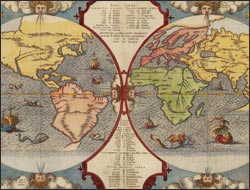
Benedict Arias Montanus sacrae geographiae tabulam…
Perhaps dampened by restrictions on the circulation of valuable geographic information, commercial map production had failed to develop within the borders of Spain. When King Philip II commissioned his subject Montanus, a Benedictine, philosopher and scientist, to compile a Bible in Latin and Hebrew, the manuscript was sent north to Antwerp for publication. It included this engraved world map, enhanced by color applied by a member of the city's limners' guild.
The double-hemisphere projection created space outside the area of cartographic content for the inclusion of explanatory text in cartouches and cherubic heads representing the north and south winds. The map shows the distribution of the Ten Lost Tribes of Israel, believed by many 16th-century theologians to be the ancestors of the native peoples encountered in the New World, Asia, and Africa. Reunification of the Ten Tribes would signal the return of the Messiah—and sanctify King Philip's aggressive pursuit of a world-spanning empire.