Explore The Popular Popple Map
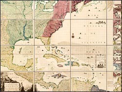
A map of the British Empire in America with the French and Spanish settlements adjacent thereto
Popple, a financial agent with New World connections, only produced one map, the first large-scale map of North America. Its impressive size required it to be printed on twenty sheets of paper. Map sellers offered it in three formats, with a corresponding increase in price: loose sheets; bound into an atlas format with an additional key map as shown below; or preassembled and mounted on linen (recreated in facsimile on wall to left).
Admired for its decorative appeal, if not its accuracy, Popple's map received immediate and widespread attention. The Board of Trade, which regulated the colonies for the crown, instructed that copies be distributed for display in public offices, and colonial elites ordered atlases and wall maps for their personal use.
A supporter of colonial trade development, Popple's intent was to present Britain's position in relation to that of France and Spain. Although he accomplished a realistic depiction of the extent of English settlement and influence in 1733, critical compatriots--suspicious of his reliance on de L'Isle's 1718 map for the geography west of the Alleghenies--accused him of favoring French claims.