In 1748, the Ohio Company of Virginia received permission to settle 200,000 acres in the area of present-day Pittsburgh. To block this encroachment, the French built two forts south of Lake Erie. As tensions escalated into confrontation, maps played a key role. In 1754, a young military officer, George Washington, sketched a map of the region, and, in 1755, three landmark cartographic contributions reached publication: the Mitchell map in London, the d’Anville map in Paris, and the Evans map in Philadelphia.
Explore Defining the Field of Conflict
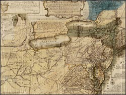
A general map of the middle British colonies, in America…
An extremely rare printing in color on silk, the map of Evans, a native-born colonial, focused attention on the disputed Ohio Valley, showing its relationship to British settlements. Evans separately issued a description of his sources: existing surveys, Indian traders, and his own firsthand observations from nearly two decades of surveying along the Pennsylvania-New Jersey-New York frontier. Considered the most proficient of colonial geographers, contemporaries valued Evans's map for its accuracy. Today it is esteemed as a milestone in the progress of American printing. Competition arose between Evans and Mitchell, whose map had been published five months earlier. Evans asserted that English territorial claims should be based on 18th-century treaty agreements alone, and should not, as Mitchell suggested, refer to precedent rights-of-discovery, in which the French had a stronger argument.