As European rulers and merchants increasingly pursued overseas exploration, trade, and colonization, the mariners in their employ felt the need for large-area maps on which they could plot transoceanic courses of constant compass bearing. In 1569, Gerhard Mercator, a friend and commercial competitor of Ortelius, published his revolutionary world-map projection, which solved this mathematical problem. A century passed before it became the preferred map projection for navigators, engineers, and military strategists.
Explore Constant Bearing
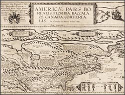
Americae pars borealis, Florida, Baccalaos, Canada, Corterealis
To compile this map of North America, de Jode, a second-generation Antwerp publisher, had access to the most recent available information, including published copies of Le Moyne's map of the southeast and the Virginia map of John White, the Roanoke colony artist. The inset figures of Algonquians were also derived from prints of White's work. After a century of exploration, little was known about the interior, and de Jode included conjectural features, reifying the eagerly-sought Northwest Passage.