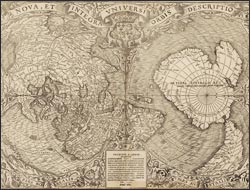
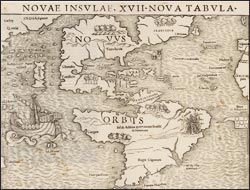
Printed maps first appeared in Europe in the late-15th century, an advancement over hand-copying that eliminated the introduction of errors during replication and made maps more widely available. To produce a woodcut map, a cartographer’s manuscript was copied in reverse onto the surface of a plank. Specialist woodcarvers then chiseled away the non-printed areas. The resulting woodblock could be inked and printed together with typeset text using the letterpresses developed during this era, which employed direct, vertical pressure to transfer ink to paper. The woodcut technique, however, did not lend itself to the fine, curved lines particularly needed for place names, or the inevitable amendments required in a rapidly changing world.
Explore Woodcut Maps
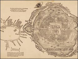
Map of Mexico City and the Gulf of Mexico
The inclusion of woodcut maps made explorers' accounts more vivid and comprehensible. This fish-eye view of Tenochtitlan, with Cortes and his forces advancing under the flag on the horizon, represents the pre-conquest Aztec capital as a wealthy and complex European-style city with, at its center, the bloody, religious practices used to justify subjugation by a Christian nation. Albeit oriented upside down by modern conventions, the Gulf Coast is relatively accurately represented, applying the name "Florida" on a map for the first time.