England’s agricultural strategies for exploiting the resources of its New World territories depended on the rapid transfer of population to the colonies and the progressive appropriation of land occupied by Native Americans. During the 1600s, as maps played an increasing role in the culture of print, the government and private investors used them as a means to exercise control over colonial territory and to make this strange, sometimes frightening, environment attractive and comprehensible to would-be colonists.
Explore England Makes Its Mark
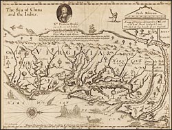
A mapp of Virginia discouered to ye falls
Farrer, an officer and investor in the Virginia Company, crafted this map, which minimizes the presence of Native Americans and emphasizes the bountiful flora and fauna. To the north (oriented right), he remarks the establishment of Maryland and the lucrative fur trade of the Swedes on the Delaware and the Dutch on the Hudson. To the west (top), only "ten days march" through the territory of "peaceful Indians," he optimistically promises access to New Albion on the Pacific coast, which Drake had already claimed for England in 1577.


