To sustain the French fur trade in North America required only a thin population of trappers and traders with access to an extensive network of Native American tribes, which penetrated farther and farther into the continent as the 17th century progressed. Adventurers and entrepreneurs seeking new routes for the efficient transportation of furs out of the backcountry joined Jesuit missionaries in exploring and mapping the Great Lakes region and the Mississippi. The Jesuit school system, which emphasized mathematics and cartography, prepared many of them for the challenge.
Explore Following a Different Path
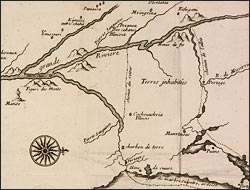
Carte de la decouverte faite l’an 1663 dans l’Amerique septentrionale
Thévenot, who specialized in printing exotic travel accounts, published excerpts from a pirated manuscript recounting the exploration of the Mississippi River by Marquette, a Jesuit priest, and the fur trader Louis Joliet in the summer of 1673. Bound into the text, this is the first printed map to show the full length of the Mississippi from Baye des Puans (Green Bay) to the Gulf. The pair had turned back at its confluence with the Arkansas River, 700 miles from the mouth, but the map extrapolates the continuation of its course.