Explore Geography Makes History
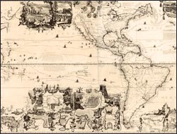
Carte tres curieuse de la mer du sud
This remarkable map of the Western Hemisphere is from Chatelain's seven-volume Atlas Historique. The complexity and beauty of the engraving demonstrates the prodigious skills of the Amsterdam mapmakers. It presents a pictorial argument for the influence of geography on history, including: portraits of explorers and circumnavigators, with descriptions of their achievements and tracings of their routes; depictions of Native American rituals at the time of contact; views of contemporary New World cities; scenes of economic activity--mining, sugar-cane processing, fishing, and hunting; and indigenous flora and fauna, most notably an anthropomorphic representation of industrious beavers at Niagara Falls. Fourteen years after Kino's map of the Gulf of California region, Chatelain equivocated by depicting California as an island, but noted that it may be part of the mainland.