In the first few decades of the 17th century, northern European nations—the English, rapidly followed by the French and the Dutch—planted permanent colonies on the eastern edge of North America: Jamestown, 1607; Quebec, 1608; Plymouth, 1620; New Amsterdam, 1624. The Spanish held the Florida peninsula and began to move north from Mexico into the Southwest, establishing Santa Fe in 1609. As expansionist ambitions stirred, maps became useful tools that gave these fragile frontier outposts the force of empire.
Explore Building Empire
Carte geographique de la Nouvelle Franse ...
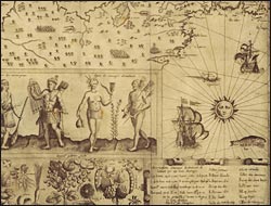
Beginning in 1603, Champlain made several exploratory voyages to North America, traveling up the St. Lawrence River into Lake Champlain, and out along the Atlantic coast, before establishing Quebec in 1608. He subsequently published a travel narrative, illustrated with this map embellished with the king's arms, images of indigenous people, and plants and animals of potential economic use. It is the first map of any part of the Great Lakes system--based on information from native informants--that offered the hope of a cross-continental route to Asia.