The rediscovery in the early 15th century of Geography—a treatise by the 2nd-century mathematician, astronomer, and geographer Claudius Ptolemy—gave Renaissance scholars ancient knowledge about the construction of maps and initiated modern scientific cartography: the use of a two-coordinate grid system of latitudes and longitudes to locate with precision any point on the surface of the earth, and three formulas by which the terrestrial portion of the sphere could be mapped or “projected” onto a flat surface.
Explore The Known World
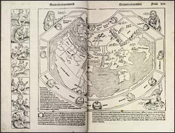
Liber Chronicarum
Ptolemy also included the coordinates of hundreds of localities, which could be used to reconstruct the known world, thought to extend over half of the earth's surface and to encompass Asia, Africa, and Europe. Mixing Renaissance science with biblical history and medieval mythology, Schedel used a Ptolemaic projection--without delineating longitude and latitude--to illustrate the division of the three continents among Noah's sons after the Flood. Popular literature of the era contributed the fabled creatures believed to exist beyond the Christian realm.