Conflicts in Europe among imperialist nations spilled over into their North American colonies. During the War of Spanish Succession (1702-1713), the French and their Algonquian allies raided settlements on the New England frontier. The English burned St. Augustine in Florida and captured Annapolis Royal in Nova Scotia—but failed to take Quebec when, lacking adequate charts, their ships ran aground in a fog on the St. Lawrence River. The Treaty of Utrecht ended the bloodshed, but its ambiguous delineation of colonial boundaries sparked a paper war between French and English cartographers.
Explore Paper War
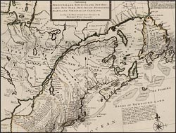
A new and exact map of the dominions of the King of Great Britain…
An engraver of northern European origin, Moll immigrated to London in 1678 and worked for other publishers before setting up his own highly successful business there in 1700. He moved in the lively circle of Enlightenment writers and scientists who frequented the city's coffeehouses. Beginning with this document--popularly known as the Beaver Map--Moll used his cartographic skills to promote the expansion of England's position in the New World fur trade. In the northeast, Moll pushed the boundary of the English colonies westward to the shores of the waterway--extending from the mouth of the St. Lawrence River inland to Lake Erie--that was critical to the transport of furs, and emphasized England's friendship with the Iroquois. Using map insets, Moll drew the viewer's attention to the Southeast, a covert sign of his support for Carolina's Indian traders, who were attempting to extend their sphere of control west to the mouth of the Mississippi.