In the contentious decade after 1763, many British colonists questioned whether King George III deserved their loyalty and, in opposition, began to identify themselves as “Americans.” In April 1775 fighting broke out at Lexington and Concord when British soldiers attempted to seize colonial arms and ammunition. British military engineers had surveyed a significant part of the colonies since 1763, but the new commander in chief, Washington, perceived the disadvantage of the colonists: most of the manuscripts were archived in London and most maps were still printed there.
Explore Revolution! Part 1
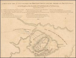
A sketch of the action between the British forces and the American provincials…
The well-connected London publisher Faden (whose partner Jefferys had died in 1771) enjoyed access to official archives, including that of the War Office. This, the earliest separately printed map of the defeat of the Provincials at the Battle of Bunker Hill, appeared only six weeks after the event. War generated a demand for maps, not only for military purposes, but also to satisfy the keen interest of the public, who had become accustomed to receiving information in cartographic format.