In late 1778, with the British capture of Savannah and Augusta, the main theater of war shifted to the South. After dealing a devastating defeat to the Americans at Charleston in May 1780, the British hoped to rally local Tory support as they moved into North Carolina and Virginia. In mid-1781, after a series of battles weakened the British army, its central command retired to fortifications at Yorktown. With support from the French on land and sea, the Americans laid siege on September 29 and commenced bombardment October 9.
Explore Revolution! Part 2
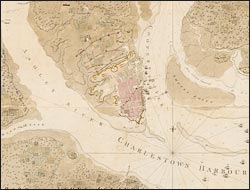
A sketch of the operations before Charlestown…
During and after the French and Indian War, Des Barres, a Swiss-born engineer trained at the Royal Military Academy, prepared navigational charts of the Atlantic Coast for the Admiralty. Returning to England in 1774, he began to compile a remarkable marine atlas, the Atlantic Neptune, which he issued in sections as completed, supplementing his own work with that of Holland and others. To address the persistent problem of representing relief, Des Barres devised a system of shading to show salient details--hills, marshes, clearings, etc.--which he used to depict the British siege of Charleston: the approach of the British navy, the final position of troops north of the city, and the attempt by the Americans to block the Cooper River by scuttling their own ships in the channel. Victory gave Britain a strategic base for their southern operations and inflicted on the Continental Army its worst losses of the Revolution.